Footnotes
(Note 1) Sediment disaster hazard zone
https://www.bousai.go.jp/kyoiku/pdf/h30_tebikisho_english.pdf
(Note 2) Real-time landslide risk map
https://www.jma.go.jp/bosai/en_risk/#zoom:5/lat:34.016242/lon:135.000000/colordepth:normal/elements:land
Introduction of a Real-Time Sediment-Related Disaster Prediction System
KOKUSAI KOGYO CO., LTD.
■Industry:Academic research, professional/technical services
| Updated | October 08, 2021 |
|---|---|
| Publication date | December 02, 2016 (Posted on June 22, 2022) |
| Sector | Natural Disasters / Coastal Areas |
Company Overview
As a leading company in geospatial information technology, Kokusai Kogyo Co., Ltd. is leading the industry to create safe and secure “Green Communities” with its expertise in social infrastructure, disaster prevention and environmental protection, and renewable energy.
Climate Change Impacts
It has been pointed out that as climate change progresses, the scale and intensity of rainfall and typhoons will increase, raising the possibility of disasters than before. The nation has become more aware of this issue by the recent heavy rainfall disasters caused by typhoons and linear precipitation belts. Real-time prediction of sediment-related disasters caused by the increasing frequency of heavy rainfall is now being increasingly required.
Adaptation Initiatives
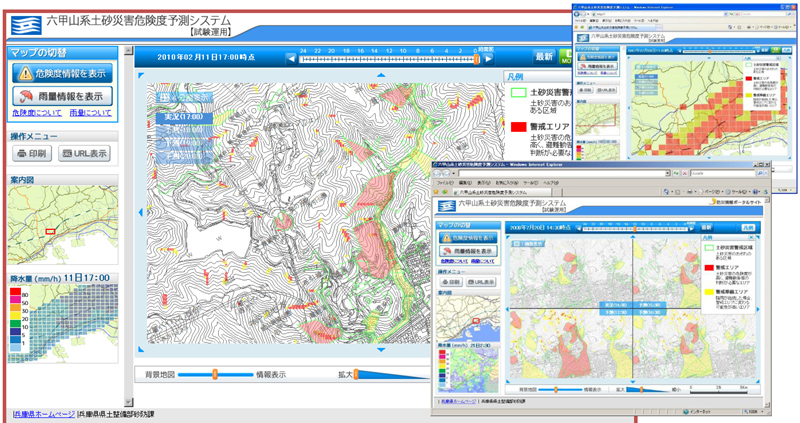
We have developed a "Real-time Sediment-Related Disaster Prediction System" that provides real-time information on the risk of sediment-related disasters, which changes every moment according to rainfall conditions. This system employs a method to predict the risk of surface collapse using a digital elevation model (DEM). The system can pinpoint the dangerous areas by quantitatively evaluating the risk of slope collapse (safety ratio), which changes every moment according to rainfall conditions, by analyzing each cell of the model with precise three-dimensional topography, ground, and radar-analyzed rainfall.
The "Sediment disaster hazard zone" (Note 1) designated by prefectural governments and the "Real-time landslide risk map" (Note 2) provided by the Japan Meteorological Agency do not take topography and geology into account when determining the risk level, which makes it is difficult to understand which landslide risk areas within the mesh are more dangerous or whether there are dangerous areas outside of the landslide hazard areas. However, by using this system, it is possible to:
- evaluate unprecedented rainfalls by using a physical model that includes topographical and geological elements
- pinpoint the dangerous areas, because the system can calculate with a minimum of 10-meter mesh data.
This system has been installed in Hyogo Prefecture and infrastructure companies (Fig. 1).
Effects/Expected Benefits
By using this system, it becomes possible for companies that own offices, properties, or facilities located on slopes or along mountains, to promptly evacuate their employees and customers, and avoid any impact.
Related sites
