Climate Monitoring and Early Warning
NEC Corporation
Rise in temperature associated with climate change is said to raise the sea level which adds to evapotranspiration and frequency of downpour, resulting in water-triggered disasters including more floods and severer landslides dealing an enormous blow to residential areas, agriculture and businesses along the rivers and coasts. NEC has demonstrated effectiveness of its flood simulation system in northern Thailand in collaboration with Thailand’s National Disaster Warning Center (NDWC) as part of the countermeasures against frequent floods in Thailand. The System enables prediction of flood inundation areas and maximum flood levels. It serves as an adaptation measure in the field of climate monitoring and early warning to issue warnings to threatened areas before the flooding occurs and to help reducing potential damage.
| Publication date | March 21, 2017 |
|---|---|
| Sector | Natural Disasters / Coastal Areas |
Company Overview
NEC Corporation, the first company in Japan associated with foreign capital was founded in 1899 as a joint venture with Western Electric Corporation. While focusing on social solution business, the Company has also promoted diagnosis for deterioration of social infrastructure using the cutting-edge ICT technology such as Big Data, anti-aging measures and disaster reduction. Its’ upcoming initiatives include promotion of disaster reduction ICT counter floods and landslides in Thailand and also to Asian neighbors leveraging its pool of experience and expertise.
Adaptation Initiatives
Contributing to minimize damage caused by flood
[Products and Technologies]
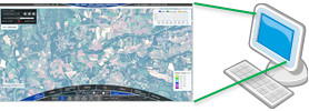
The flood simulation system is one of the flood disaster modules of NEC’s "Integrated Risk Management System" covering a wide range of natural disasters including floods, landslides and earthquakes. The System consists of a shared risk management platform with such functions as data integration, visualization, and early warning, and disaster modules specialized for each particular disaster. The disaster modules and functions are selective for individual application as required or combined to predict multiple disasters simultaneously.
The flood simulation system is characterized as follows.
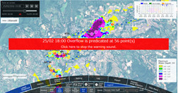
- Simulations based on meteorological data (observed rainfall and forecast rainfall), topographical data (elevation values, land use purposes), and watercourse data (river networks, water levels, sewer systems, etc.), making it possible to predict flood inundation areas and maximum flood levels.
- Detailed simulations using a triangular mesh measuring 50m on each side, hourly-basis prediction for a period of up to seven days in advance, allowing NDWC to issue pre-warnings to threatened areas.
- Identification of areas at risk of flooding even during periods when no disaster is forecast by performing simulations using previous rainfall data, contributing to hazard mapping.
[Project Details]
NEC Corporation in collaboration with Thailand’s National Disaster Warning Center (NDWC) and Japanese Embassy of Thailand, has conducted a trial of its flood simulation system to predict the inundation areas in Uttaradit Province in Northern Thailand during the period from November 2015 to March 2016. It was the first Japan-Thailand cooperation project in the field of disaster reduction ICT conducted as part of the "Research and study for the development of a flooding simulator in Thailand" project commissioned by Japan's Ministry of Internal Affairs and Communications.
 This article is based on the report of the Ministry of Economy, Trade and Industry "FY2016 program: Visualizing contribution of Japanese companies to adaptation activities in developing countries"
