Identifying Flood Risks Inside Buildings and Utilizing Information for Risk Management
TAISEI CORPORATION
In recent years, there has been more damage from floods than ever expected. The Flood Prevention Law is being revised in anticipation of an increase in strong precipitation and more severe flooding due to global warming. Although local governments have published hazard maps to estimate the depth of inundation, they only show the approximate area, and it is difficult to estimate the damage to individual buildings.
TAISEI CORPORATION has developed T-Flood Analyzer, a system for assessing the flood risk inside the buildings. With this system, it is possible to estimate the damage according to the actual situation. Appropriate countermeasures based on the results will not only reduce the number of damaged buildings, but also maintain the function, performance, and asset quality of the buildings, which will lead to the adaptation to climate change impacts.
| Publication date | April 28, 2017 (Posted on July 19, 2022) |
|---|---|
| Sector | Natural Disasters / Coastal Areas, Industrial and economic activities |
Company Overview
Since its establishment in 1873, TAISEI CORPORATION has been engaged in a number of pioneering projects in extensive fields, including architectural/civil engineering design and construction, environment, engineering, nuclear power, and development, using our advanced technological capabilities cultivated over the years.
Today, the role of the construction industry is not limited to the simple construction of structures. It is becoming more complex and diverse, including the coexistence of people with nature and countermeasures against natural disasters such as earthquakes.
Based on the group philosophy, “to create a vibrant environment for all members of society”, we are conducting corporate activities with our big goal of contributing to the sustainable development of society through the development of a safe and comfortable living environment.
Adaptation Initiatives
[Products and Technologies]
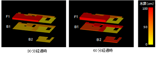
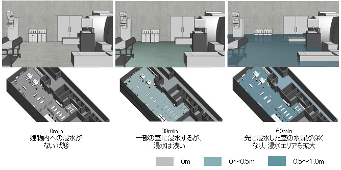
Our system T-Flood Analyzer is an assessment and diagnosis system capable of visualizing the flood risk inside buildings due to heavy rains, floods and tsunamis in a short period of time. It has the following characteristics which is effective from the viewpoint of risk management and space utilization.
- High accuracy due to analysis focusing on the difference in levels between the inflow route and the floor
- Applicable not only to new construction simulations but also to existing facilities.
- In addition to wide-area damages from floods, individual conditions such as rainwater inflow via ramps can also be analyzed.
- The analysis results of the flooding inside the building can be shown on display with 2D or 3D images.
- Possible to compare and verify the effects when considering various measures.
In addition, by linking the system with the BIM (Building Information Modeling) data, the analysis of the inundation condition inside buildings and the 2D or 3D result can be shown on display faster.
[Project Details]
To carry out the analysis by this system, it is necessary to collect specific information (hazard maps, maps of expected flooding areas, estimations on the precipitation condition and elevation of the surrounding areas and sites, floor levels, detailed conditions specific to the building such as the openings of the building.) Collecting information and organizing, communicating, and sharing the content of the information helps to raise the risk awareness of the building owners and to promote risk communication within the organization.
The following are some typical applications of this system.
- Existing facilities located within the expected flooding areas on the flood hazard map
- Facilities that are out of the expected flooding area but have important functions underground, and are susceptible to flooding due to the specific conditions of the building.
- Verification of the building design before construction.
In the future, we plan to actively develop applications such as predicting the depth of the flooding in the surrounding areas of the buildings and linking the system with evacuation simulations.