Northern Sea Route Support Service
Weathernews Inc.
| Publication date | April 03, 2018 (Posted on July 11, 2022) |
|---|---|
| Sector | Industrial and economic activities |
Company Overview
Weathernews Inc., the world's largest meteorological and marine information service company (TSE 1st section), was founded in 1986 by Hiroyoshi Ishibashi, who experienced a marine accident in 1970 and became determined to protect the lives of the mariners.
In recent years, countermeasures against increasing and diversifying weather risks, such as typhoons, hurricanes, cyclones, and floods caused by torrential rain, have become an increasingly important theme for everyday life and industries. We have developed our proprietary sensory infrastructure to accurately identify the meteorological and geological phenomena occurring in various regions. By gaining a deep understanding of risks in each country, we have been able to provide weather services and risk communication services that are truly useful to each and every person in the world, and we are currently providing these services to customers in approximately 50 countries around the world, 24 hours/365 days, together with the local communities.
Adaptation Initiatives
Sea ice in the Arctic Ocean is dramatically decreasing along with global warming. While the decrease in sea ice of the polar regions is considered to be a negative impact of global warming, it is becoming possible to navigate through the Arctic Circle with the appropriate information to support navigation, which is something that was not possible before. The development of the Northern Sea Route is also an adaptation business that takes a positive view of global warming.
For example, the Northern Sea Route can shorten the time between Japan and Europe by half compared to that via the Cape of Good Hope and by 40% compared to that via the Suez Canal. Shipping companies can significantly reduce fuel costs and do not have to be concerned about being targeted by pirates. However, because of the sea ice in the Arctic Ocean and the severe weather conditions, information on appropriate routes and accurate weather is indispensable for shipping companies.
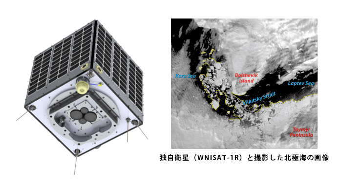
We therefore began to explore the possibility of the Northern Sea Route Support Service. At the time, there were several satellites capable of observing the Arctic Ocean, but the resolution for capturing images of sea ice was low, and the clouds in the sky made it difficult to sufficiently determine the sea ice conditions. To solve this issue, we developed and launched our own satellite (WNISAT-1R) in collaboration with a start-up company, which constantly observes the sea ice in the Arctic Ocean and enables Weathernews to provide a navigation support service using the sea ice forecast information.