Controlling the Walls of Mines Using High-precision Satellite Positioning (shamen-net)
KOKUSAI KOGYO CO., LTD.
| Updated | October 08, 2021 |
|---|---|
| Publication date | December 02, 2016 (Posted on June 22, 2022) |
| Sector | Natural Disasters / Coastal Areas |
Company Overview
As a leading company in geospatial information technology, Kokusai Kogyo Co., Ltd. is leading the industry to create safe and secure “Green Communities” with its expertise in social infrastructure, disaster prevention and environmental protection, and renewable energy.
Climate Change Impacts
There used to be more than 1,000 open-pit mines in Japan but many of them have been abandoned or closed, and it is estimated that only about half of them are currently in operation compared to their peak period. In open-pit mines, it is an important issue from the standpoint of safety and protection of the landscape to proceed mining while forming a stable wall at the same time. The Mine Safety Act also requires operators to take risk prevention measures for closed mines. However, it has been pointed out that as climate change progresses, the intensity of rainfall and the scale and strength of typhoons will increase, which raises the possibility of the occurrence of disasters with greater impact. The nation has become increasingly aware of this from the unusual occurrence of typhoons in summer that have hit Japan in the recent years.
Adaptation Initiatives
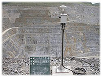
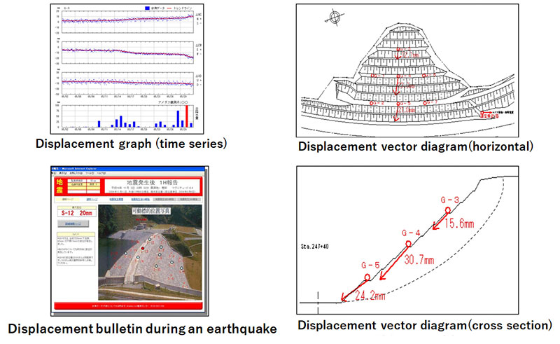
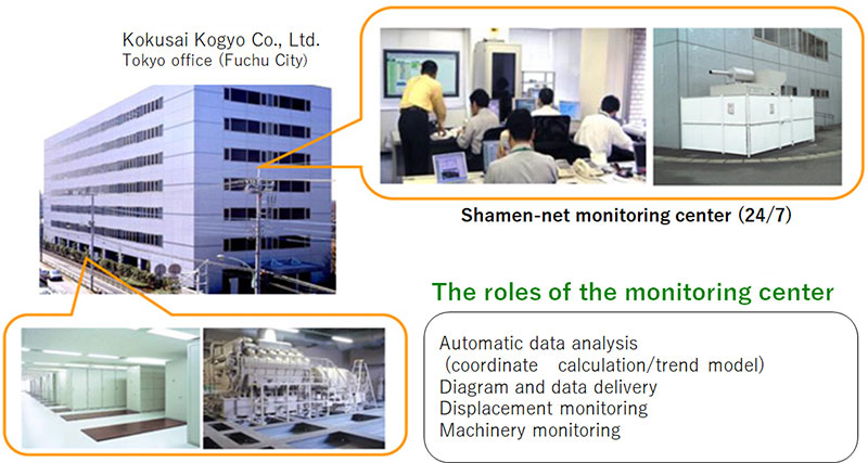
In response to the increasing importance of managing the walls of mines in the event of a disaster, we are proposing "shamen-net for observing slope anomalies," a service that measures real-time displacement of slopes, evaluates stability, and provides useful disaster prevention information online. This is a maintenance and management support service that uses automatic GNSS/GPS to measure the displacement of the ground or structures in 3D and in millimeters on a real-time basis, and full-time engineers monitor the displacement 24 hours/365 days (Fig. 1, 2, 3). This service is not affected by weather conditions and can be used during night hours. Useful disaster prevention information such as measurement data is provided online for a fixed monthly fee. The features of this service are described below.
- We use the latest GNSS/GPS automatic measurement system to measure displacements of the ground or structures in 3D, and in millimeters, on a real-time basis.
- Our full-time engineers monitor the displacements 24 hours/365 days and notify the customer via telephone or e-mail when any anomaly is detected.
- We offer analysis using the latest methods with highly precise (approximately 2 mm) measurements.
- Customers can use the Internet (or mobile phone) to check the latest measurement results.
- In addition to the measured displacements, we also deliver climate information such as rainfall and weather forecasts.
- The service is available for a low, fixed monthly fee (including GPS costs and communication expenses).
Effects/Expected Benefits
The following effects are expected from the use of this service.
- Real-time monitoring with highly accurate measurement results.
- Can be operated regardless of weather conditions and also during night hours.
- By collecting data online, it is possible to monitor within the office during torrential rains and during night hours, improving the safety of staff and workers.
- Reduce manpower for measurement on site.
- Enables information-oriented operation when used for construction management.
- Monitoring can be continued after construction to determine the effectiveness of countermeasures and for maintenance management, and to clarify the performance of the design or cost effectiveness of reinforcement measures.