Real-time flood simulator "DioVISTA/Flood"
Hitachi Power Solutions Co.,Ltd.
| Publication date | September 10, 2020 (Posted on March 15, 2022) |
|---|---|
| Sector | Natural Disasters / Coastal Areas |
Company Overview
Since its establishment in 1960, Hitachi Power Solutions, as a member of the Hitachi Group, has provided products, services, and solutions in the energy infrastructure-related field. In recent years, we have promoted the provision of the Digital × Operational Technology (OT) Service Platform, a high-value-added service that integrates OT and Information Technology (IT) digitally. We are contributing to the development of our customer business by leveraging the presence of specialists in diverse fields with advanced technologies and the strength of nationwide deployment of our service bases.
Climate Change Impacts
Severe flood damage occurs frequently in various regions. It is estimated that climate change increase flood risk in the future by a factor of 2 to 4. Advanced flood risk information and flood damage prediction are required in order to minimize the damage.
Adaptation Initiatives
"DioVISTA/Flood" is software for simulating flood damage on three-dimensional maps. Since its launch in 2006, it has been used in a variety of operations both in Japan and abroad to combat flood damage. For example, some of the flood hazard maps for class A and class B rivers in Japan have been developed through the use of DioVISTA/Flood.
The main feature of DioVISTA is calculation speed. Its faster simulations are enabled by patented technology called "Dynamic DDM" (Note 1). Timely predictions can be done by the technology. DioVISTA/Flood imports rainfall forecast data and predicts water levels in rivers and dams, and flooded areas in urban areas (Figs. 1 and 2). DioVISTA/Flood visualizes the simulation results on the map, and sends alert notifications to the user.
In addition, It is also possible to perform a simulation by inputting the expected situation such as what happens if the river overflows due to heavy rain once in 1000 years and the levee breaches. It is simulated according to Ministry of Land, Infrastructure, Transport and Tourism (MLIT) "Inundation Risk Area Mapping Manual (4th Edition)", and it is possible to obtain high accuracy results.
DioVISTA/Flood Free Edition is available free of charge (Note 2). Once download and install it, you can perform the simulation immediately with no additional procedure such as user registration.
Effects / Expected Benefits
Utilization of DioVISTA/Flood will respond to SDGs's Goal 13 "Take urgent action to combat climate change and its impacts" and will lead to enhanced resilience and adaptability to flood damage caused by climate change. In addition, by quantifying the risk of flood damage, we promote appropriate land use and contribute to urban development in harmony with nature. Furthermore, we support sustainable societies that can reduce losses from flood disasters and overcome enormous risks.
The results of the simulation can be used to study the following measures.
By using this software, it's possible to take measures based on flood risk information.
(Use cases)
- It can be used as a reference when designing insurance at a non-life insurance company.
- It is also useful for companies when designing new factory strong against flood damage.
- It can also be used for building a business continuity plan (BCP) for flood damage.
- It can be used as a guide for issuing evacuation orders in local governments.
Footnote
(Note 1) Japanese Patent No. 4761865, which is received the Kanto Regional Invention Award for 2019 by Japan Institute of Invention and Innovation
(Note 2) Go to https://app.hitachi-power-solutions.com/diovista_flood/#!Documents/cover_download.html
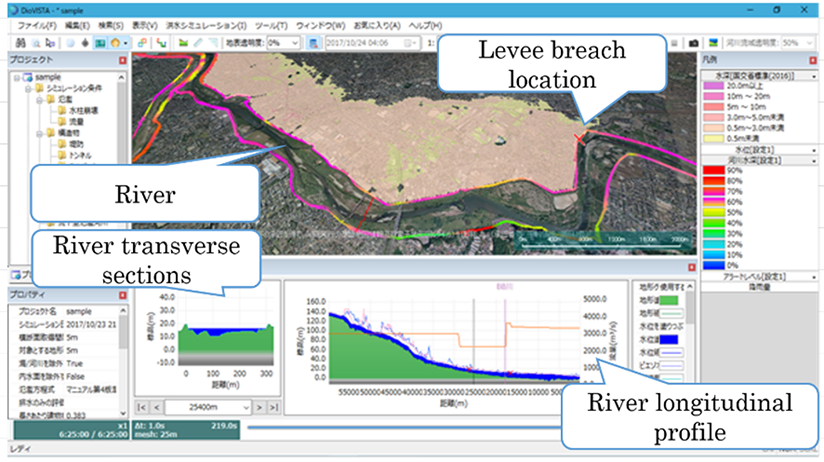
Fig. 1 Examples of flood analysis in urban areas by DioVISTA/Flood
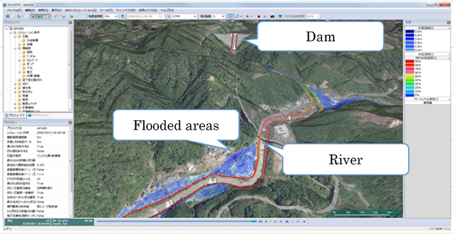
Fig. 2 Examples of flood analysis downstream of dams by DioVISTA/Flood
