Footnote
(Note 1) Developed through joint research with Aon Group Japan, Ltd. and Yokohama National University
(Note 2) Survey conducted by Aioi Nissay Dowa Insurance in June 2019
Real-time Damage Prediction Website "cmap"
Aioi Nissay Dowa Insurance Co., Ltd.
Industry: Finance and insurance
| Publication date | August 5, 2021 (Posted on June 2, 2022) |
|---|---|
| Sector | Natural Disasters / Coastal Areas |
Company Overview
Aioi Nissay Dowa Insurance Co., Ltd. is engaged in the P&C insurance business, the core business of the MS&AD Insurance Group Holdings, Inc. We are strengthening our partnerships with the Toyota Group and Nippon Life Group to make the most of our features, and continue to develop "community-based" operations.
Climate Change Impacts
In the recent years, large-scale natural disasters, which are assumed to be caused by climate change, have continuously occurred within and outside Japan, causing serious damage to people's daily lives, business operations, and the natural environment. In the event of a natural disaster, a quick and adequate initial response is urgently required, but due to the lack of information, it is difficult to estimate the affected area and scale of the disaster. It is also the responsibility of the P&C insurance companies to promptly proceed with the acceptance of damage from customers and the payment of insurance claims under any conditions, which requires early determination of the scale of damage.
Adaptation Initiatives
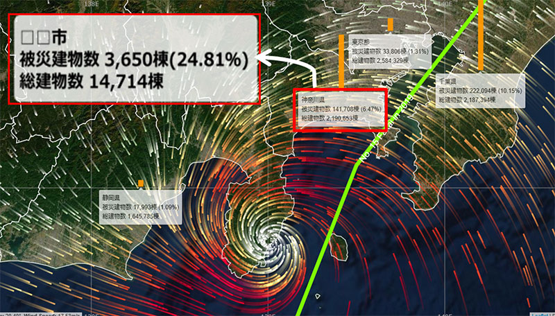
We have developed a real-time damage prediction website, "cmap" (Note 1), to determine the scale of damage at an early stage. “cmap” is a website that predicts the number of damaged buildings and the rate of damage for each city, ward, and town immediately after a torrential rain or earthquake, and even before a typhoon strikes, and displays the results on a map (Figure 1). At regular times, the website provides simulations using major typhoons, torrential rains, and earthquakes that have occurred in the past, as well as global weather information. It can also display hazard signs for floods and sediment disasters (flood risk, landslide warning, landslide danger) published by the Geospatial Information Authority of Japan.
“cmap” is the world's first website (Note 2) in the following four aspects.
- It is available to the public free of charge. Anyone can use the service from any device, including smartphones, computers, and tablets, and there are no registrations or other required procedures.
- “cmap” displays the estimated number of damaged buildings and damage rate in each prefecture or city before typhoons make landfall (until seven-day onward).
- The fact that it can predict the number of damaged buildings and the rate of damage. Assuming that all buildings in Japan are covered by fire and earthquake insurance, it can estimate the number of buildings that may be eligible for insurance payments.
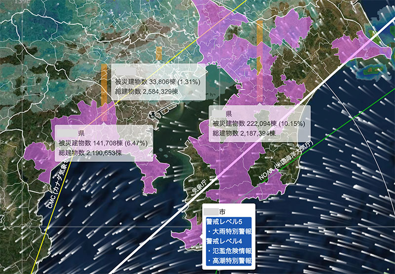
- Real-time updates. Earthquakes are displayed and updated about 10 minutes after the detection, and typhoons and torrential rain are displayed and updated every hour. The display of information for areas with warning levels 3, 4, and 5 is updated every minute, and the screen is automatically updated every 10 minutes (Figure 2).
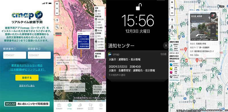
In addition, we have developed an application called "Damage Prediction Application cmap," which has the function to send alerts for emergency information on disasters, and released it free of charge (Figure 3). The application allows users to register their locations by zip code, and sends notifications of emergency information (weather warnings, evacuation orders, etc.) in the cases of a disaster at their current and registered locations. It also provides a function to display emergency evacuation sites designated by the local government on the map, so that users can easily check them even when they are out of town.
Effects / Expected Benefits
In cooperation with JX PRESS Corporation's FASTALERT service, which analyzes and displays text and images from social media, cmap also provides a service for sharing information on social media (videos, images, and texts) that has been classified as weather, disaster, or lifeline.
As a disaster prevention and mitigation solution that allows users to check dangerous scenarios in various areas in almost real time even before a disaster strikes, it is expected to contribute to supporting the promotion of DX (digital transformation) by the local governments, police, fire departments, and Self-Defense Forces, which are responsible for the safety of their communities. It is also expected that the tense images will trigger changes in actions and prevent delays in escape.
The system was highly recognized for its contribution to quick rescue and support activities, and for its role in disaster prevention and mitigation, and was awarded the Grand Prize at the 29th Global Environment Award.
Related sites
- Aioi Nissay Dowa Insurance Co., Ltd. web page "Real-time Damage Prediction Website, cmap"
- Aioi Nissay Dowa Insurance Co., Ltd. "Received the Grand Prize at the 29th Global Environment Award - real-time natural disaster damage prediction website “cmap.dev” receives high recognition -" (February 28, 2020)
