Footnote
(Note 1) Remote sensing technology is a technology of “probing without touching the target”. Investigation through the use of proper sensors equipped on satellites is called Satellite Remote Sensing. Sensors equipped on satellites observe electromagnetic waves emitted from the sun or from the satellite itself reflected by the sea, forests, cities, and clouds. The obtained data provide a variety of information including vegetation conditions, land/sea surface temperatures, surface altitudes, and meteorological data.
(Note 2) SDB (Satellite-Derived Bathymetry) refers to a method to survey shallow waters using satellite data.
(Note 3) AW3D is a product jointly developed and sold by RESTEC and NTT DATA Corporation. Unlike conventional 3D data obtained by analyzing satellite images of the Earth's surface, AW3D is able to produce and provide 3D data of any place on Earth with a short delivery time, made possible by combining the latest IT technologies, including Multi-View Stereo Processing—AW3D's unique image processing technology—as well as AI, big data, and cloud computing.
Coastal Information Mapping Service
Remote Sensing Technology Center of Japan
| Publication date | August 10, 2022 (Posted on May 10, 2024) |
|---|---|
| Sector | Natural Ecosystems / Natural Disasters / Coastal Areas |
Company Overview
Remote Sensing Technology Center of Japan (RESTEC) was established with the aim to “establish remote sensing technologies as a form of social infrastructure through comprehensive research and development, raising of awareness, and human resource development in the field of remote sensing, and by doing so, contribute to the development of social economy and improvement of the people’s lives” and has been engaged in the areas of disaster prevention, social infrastructure, and geospatial information.
Climate Change Impacts
Surrounded by the sea, Japan has enjoyed the full benefits of marine organisms as a source of livelihood. In the recent years the ecosystem has been affected by factors such as rising seawater temperatures caused by climate change. For example, seaweed and seagrass beds play a significant role in controlling the marine ecosystems, but because they are distributed close to the coastline and in shallow areas, they are susceptible to environmental changes. In order to maintain and preserve the marine ecosystem and environment, it is necessary to be aware of where the seaweed and seagrass beds are distributed.
Outside Japan, storm surges and tidal waves caused by cyclones are also a major factor in natural disasters in island countries. The effects of the rising sea surface temperatures due to climate change are expected to submerge coastal areas, as well as increase flooding damage due to cyclone storm surges and tidal waves.
Many risks are identified as the impact of climate change, including the increased risk for human lives, injury, health issues, and economic disruptions in coastal lowlands, small island developing states, and other small islands.
Adaptation Initiatives
RESTEC provides various solutions for coastal areas with our marine environment information services using remote sensing technology (Note 1, Fig. 1) including the two solutions below.
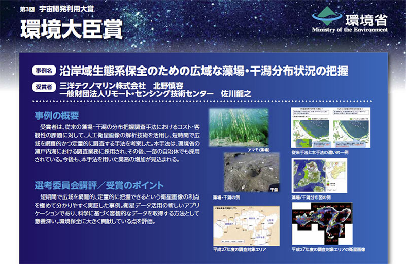
(1) Solution by analyzing the distribution of seaweed/seagrass beds and tidal flats and support our users' response to climate change: It is necessary to map the distribution of seaweed/seagrass beds over a wide area to monitor and preserve seaweed/seagrass beds. Conventional surveys were conducted mainly by diving which provided limited results, but high spatial resolution satellite images have enabled efficient and quantitative ascertainment of the distribution of seaweed and seagrass beds over wide areas.
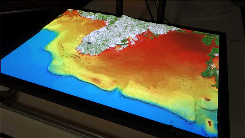
(2) Solution by creating topographic data (elevation, etc.) for land and areas near the shore where the depth is shallow and analyzing satellite data: Basic data can be created for storm surge and storm wave simulations in island countries with low elevation by utilizing and applying coastal topographic information obtained from satellites.
The seaweed and seagrass bed distribution map based on solution (1) is used for distribution surveys for the purpose of environmental conservation. It has been adopted by the Ministry of the Environment for a survey in the Seto Inland Sea, and is also used for municipal operations (Fig. 2).
In addition, by solution (2) future sea level rise projections and flooding area projections due to climate change can be calculated and risks can be assessed. This will contribute to climate change adaptation measures, such as providing hazard/risk maps for BCP and land use projects for key infrastructure such as airports (Fig. 3).
Effects / Expected Benefits
It is expected that the use of remote sensing technology in the marine field, both within and outside of Japan, will lead to the assessment of and strengthening of adaptation measures to climate change.