Development of a city resilient to urban flooding – Moving to a new stage of sewerage improvement
Yokohama Station, one of the major terminals in the Tokyo Metropolitan area, is the gateway to Yokohama City and it is surrounded by many commercial facilities. In October 2004, the station sustained severe damage by torrential rain due to Typhoon Ma-on and its underground facilities were partly flooded. In the aftermath of the disaster, based on the “Excite Yokohama 22 (Yokohama Station area development plan),” Yokohama City launched the development of storm sewer trunk lines to prevent Yokohama Station and its surroundings from suffering severe flooding even if the area has an hourly rainfall of 74 mm, roughly equivalent to that by Typhoon Ma-on (an hourly rainfall of 74 mm is considered to correspond to a rain that occurs once in 30 years or one with a 30-year return period) . In 2017, the “Excite Yokohama 22 Center Zone” around Yokohama City was designated as the first “urban flood hazard zone” in the country and began to aim for a city resistant to an hourly rainfall of 82 mm (rain with 50-year return period) using rainwater harvesting facilities to be developed by private businesses. The efforts by Yokohama City is attracting attention as an advanced challenge to fight urban flooding while torrential downpours are hitting various areas across the country due to climate change. Sewerage development requires long-term vision, a huge budget and a consensus among the residents. We interviewed Hideaki Murakami and Ryo Hakoda at the Sewerage Works Management Division, the Sewerage Planning and Coordination Department, the Environmental Planning Bureau of Yokohama City about their efforts and determination to protect citizens from flooding.
Storing rainwater 1.3 times as large as Yokohama Stadium in great-sized storm sewer trunk lines
First of all, please tell me about the role of a sewer system in protecting the city from urban flooding. Urban floods are divided into “inland flooding,” which is an overflow of rainwater due to insufficient drainage capacity of a sewer system, and “river flooding.” How is Yokohama City improving the sewer system as measures against inland flooding?
We are improving the sewer system for two main purposes. One purpose is to carry sewage to the treatment facilities. The sewered population of Yokohama City is almost 100%. The other purpose is to discharge rainwater into the ocean or a river or store it in case of heavy rain to protect the city from flooding. Generally speaking, a combined sewer system designed to carry sewage and rainwater in the same pipes is used in an area provided with the sewer system from a long time ago. In an area provided with a sewer system recently, sewage and rainwater are carried in separate sewers.
As a recent large-scale measure against inland flooding, “Nippa-Suehiro trunk line” for storing rainwater in case of torrential rain was put into service in 2011 (Total project cost of 100 billion yen). This line protects the lowland including the Tsurumi River basin repeatedly struck by inundation before. That has increased the protection capacity from an hourly rainfall of 50 mm (rain with a 5-year return period) to 60 mm (rain with a 10-year return period).
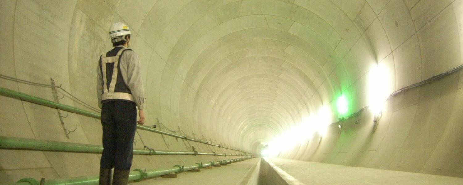
The Nippa-Suehiro trunk line buried deep under the ground is 20 km long. The largest pipe diameter is 8.5 m and the pipe is large enough for a wheal to fit in. Although it partly discharges rainwater into the sea with a pump, the line holds 410,000 m3 of water, which is 1.3 times as large as Yokohama Stadium. When we had heavy rain due to Typhoon Phanfone in October 2014, the Nippa-Suehiro trunk line held about 380,000 m3. Together with a stormwater management pond and other similar facilities, it stored a total 749,000 m3 and played a large role in reducing flood damage.
We set the target rainwater control level at an hourly rainfall of 60 mm in the entire city. However, as to the target for high altitudes that drains by gravity, we set the immediate target at an hourly rainfall of 50 mm.

Yokohama Station area to be improved to deal with torrential rain with a 30-year return period
Why did you design the Excite Yokohama 22 centering Yokohama Station to deal with an hourly rainfall of 74 mm (rain with a 30-year return period)? What efforts are you planning to achieve the target?

Nine railway lines of six companies, including the JR Tokaido Line and the Sotetsu Line, run into Yokohama Station. It is the gateway to Yokohama City and 2 million people a day use the station. Commercial buildings stand in close proximity to the station. The underground mall is always busy. Katabira River runs near the area and the area easily collects water because of its topography. When hit by Typhoon Ma-on in October 2004, significant damage resulted in and around Yokohama Station. A total 190 inundation cases below or above floor level occurred. Surface runoff flowed into basements. From that experience, the departments on the river, sewer system and city development are working closely with one another to develop safety measures against inland flood for the “Excite Yokohama 22” (formulated in 2009), large-scale redevelopment of the whole Yokohama Station area. In Typhoon Ma-on, we had the maximum hourly rainfall of 76.5 mm (measured at the Noba Fire Station Branch Office, the Fire Bureau of Yokohama City) and therefore we have decided to have the Excite Yokohama 22 area (about 140 ha) withstand an hourly rainfall of 74 mm.
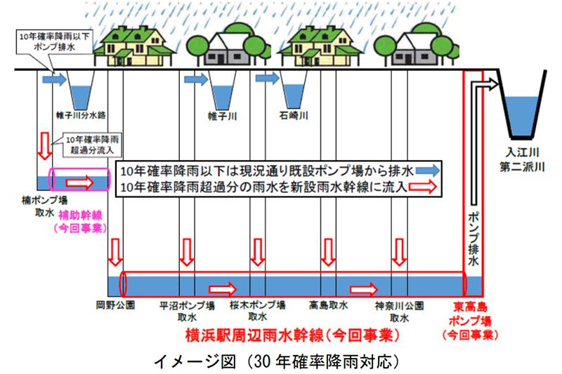
To achieve the target, we will newly build Yokohama Station area storm sewer trunk line (tentative name) and Higashi-takashima pump station. We are planning to start the construction of both facilities in 2020 and put them into service in 2030. The new storm sewer trunk line will be 4.8 km in length and 3.75 m in inside diameter. A tunnel will be excavated using the shield tunneling method at a depth of 60 m. The project is estimated to cost 41 billion yen in total.
There are five pump stations around Yokohama Station to discharge rainwater into rivers. Some of them were put into service in 1970. We need to do something on the decrepit facilities. All those stations, however, are located near the station and it is difficult to acquire a site for rebuilding. We will renew the facilities without reducing the current rainwater drainage capacity, utilizing the new storm sewer trunk line.
Up to an hourly rainfall of 60 mm, rainwater will be discharged from the five pump stations. If the rainfall exceeds 60 mm, excess rainwater will be flowed into the new storm sewer trunk line and discharged from the Higashi-takashima pump station. Other measures against flooding for the Excite Yokohama 22 include river improvement, land raising and installation of flood barriers at the entrances to the underground mall, implemented in cooperation with the national government, the prefecture and businesses.
The city project aims at a rainfall of 74 mm but you are seeking 82 mm in the future with the help of private businesses. What advantages you will gain from the designation as an urban flood hazard zone?
An urban flood hazard zone is an area where you need to take measures against flooding by torrential rain working with private businesses. Based on the Sewerage Service Act revised in 2015, the Excite Yokohama 22 Center Zone was designated as the first urban flood hazard zone in the country in 2017. The designation enables us to receive a national government’s subsidy on the works by private businesses, for instance, the development of rainwater harvesting facilities.
The city development guidelines for the Excite Yokohama 22 provides as a basic rule that a rainwater harvesting facility should be installed in the building premises in the large-scale development of the Center Zone (a site area of 5,000 m2 or more). We are now constructing the first rainwater harvesting facility with a capacity of approximately 170 m3 underground in a skyscraper under construction near the west exit. If the requirements are met, 1/3 of the cost of a rainwater harvesting facility is covered by a national subsidy and another 1/3 by the municipality (Yokohama City). All the private business has to pay is 1/3 of the cost. In case of heavy rain, rainwater is stored in this facility. It will be discharged into the sewer system after danger of flood has passed. Implementing those measures, we will protect the city from flooding even in the rain as heavy as an hourly rainfall of 82 mm.
Expecting mutual help and self-help besides public help
These days, heavy rain with an hourly rainfall of around 100 mm has been striking various places across Japan. In Hiroshima, 74 people were killed or missing (August 2014), Kinugawa River burst its levee in the Kanto and Tohoku areas (September 2015) and 41 people were killed or missing in northern Kyushu (July 2017). How are you prepared for torrential rain of an unexpected scale?
The topography of Yokohama city consists of hills, plateaus, lowlands surrounded by many rivers, and coasts. As more and more hills are being developed into residential land, agricultural land and woods are disappearing. That is reducing the water control and retention capabilities. If it rains heavily, water tends to rush into lowlands. At the same time, river improvement and the safety level of flood control are significantly enhanced. We are now able to deal with rain as heavy as it used to cause inundation. However, torrential rain occurs much more frequently than before due to climate change. According to the Ministry of Land, Infrastructure, Transport and Tourism, the occurrence of torrential rain with an hourly rainfall of 50 mm or more was 176 per year on average between 1976 and 1988, 202 between 1989 and 2000 and 229 between 2001 and 2012. It has been increasing in a long-term view. It is essential to take further precautions against great urban flooding, considering typhoons and torrential rain of an unexpected scale.
The city has made the “Inland Flood Hazard Map” of each of the 18 wards to encourage citizens to always be ready for disasters and learn what to do in case of danger. The maps show the areas likely to be inundated in case of heavy rain (a maximum hourly rainfall of 76.5 mm) exceeding the drainage capacity of the sewer systems. The areas are color-coded according to inundation depth.
The flood of the west exit of Yokohama Station in 20014 even inundated basements. What prevention measures are you taking for the underground mall?
If the underground mall is flooded, a large quantity of rainwater rushes into it. The space is limited underground and the water level is likely to reach the ceiling very quickly. If the electrical equipment is covered with water, a power outage may occur. There will be no lighting. The elevators will stop. People have to use the stairs to evacuate. Furthermore, if you are underground, you may not notice changes in the weather and might fail to escape in time. In the flood of 2004, divers at the Nishi Fire Station searched the shops in the mall to make sure that no one was trapped.
Measures against flooding have been implemented. For instance, the administrator of the underground mall has installed flood barriers at the entrances of the mall. The city is considering introducing the sewer water level informing program. Under the program, if the water level in a sewer system reaches a dangerous level, the information is provided to the administrator of the underground mall and disaster preparedness personnel. This program is specified in the 2015 revision of the Flood Control Act. It is aimed at providing water level information of sewer systems to help flood prevention activities. We installed water level gauges in four manholes at the west exit of Yokohama Station in December 2017 and started water level measurement. We are verifying the accumulation of water level data, the accuracy of the measuring instruments and the appropriateness of their locations to ensure that we can provide information effectively.
You are giving a subsidy for the installation of drywells. I’ve heard it attracted attention among C40 Cities Climate Leadership Group.
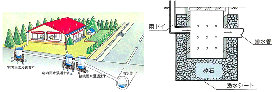
Drywells are used for groundwater recharge and reduction in rainwater runoff. In the past, for example, out of 100 of a rainfall, 50 soaked into the ground and 50 ran off. Nowadays, only 25 soaks into the ground and 75 flows over the land surface because of the development of residential land and paving. A drywell has holes on the sides and the bottom and rainwater collected in the tank soaks into the ground. We grant a subsidy of 15,000 yen for the installation of a drywell (150 mm in inside diameter) at a private residence. Drywells are often not suitable for an area abounding with groundwater or a steep slope. To provide such information, we issue a map for drywell installation.
C40 is a network of the world’s big cities to cooperate in addressing global warming. Yokohama and Tokyo are participated from Japan. We gave a presentation on our effort using drywells at a working group held in Dubai, the United Arab Emirates in January 2017. It was highly regarded by the participant cities as citizen-participation efforts.
What are the hard parts of sewerage projects?
To develop a citywide sewer system to withstand an hourly rainfall of 74 mm , it will require an unimaginably large amount of money and time although only limited funds are available. It is very difficult to predict what fierceness of torrential rain is going to fall in which area. We are considering using flood simulations in addition to the past flood records.
We will promote “public help” to disseminate flood prevention measures and information as well as “self-help” to protect ourselves and “mutual help” to help each other in communities, working with various entities. As urbanization and climate change are accelerated, we need citizens’ cooperation in utilizing sewerage for flood prevention. For example, citizens can cooperate by not draining a bath in case of heavy rain or by getting sandbags ready. We organize a lecture at elementary schools and explain daily preparation and cautions in case of heavy rain using the Inland Flood Hazard Map and other materials.
At an event on flood prevention, a resident of a downstream basin of the Tsurumi River came to me and thanked saying, “We used to have so many floods and I had to pull out and place all the drawers on the desk when I left the workplace. (Thanks to the completion of the Nippa-Suehiro trunk line) Now we don’t have to do that.” I felt we were of some help with reduction in flood-prone areas. I was glad I was engaged in this job.
(Posted on April 18, 2018)
References
