Climate change impacts
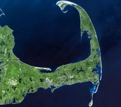
Cape Cod (Fig. 1), which forms the eastern edge of Massachusetts, is a low-lying peninsula with a long shoreline. Floods frequently occur in the region. Factors that increase this risk include sea level rises due to nor'easters (Note 1), extratropical cyclones, heavy rainfall associated with hurricanes, high waves, storm surges, and global warming. In Barnstable County, which spans the entire cape, many of the low-and middle-income real estate is located in low-lying areas that are linked to tides and is facing an increased risk of flooding. According to NOAA tide gauge at Woods Hole, Massachusetts (Note 2), the tide level has risen by more than 9 inches (about 23cm) since 1932.
Adaptation activity
Residents of Barnstable County and 15 other local authorities in the United States and have been able to insure their assets against flood damage with the National Flood Insurance Program (NFIP) for some time. An issue in this system is that premiums charged by the NFIP were not sufficient to also cover flood damage risks to buildings that were constructed prior to the establishment of the program (Note 3), this led to a corresponding increase in premiums. There are, however, ways to minimize the increase in premium costs; local authorities are attempting to simultaneously reduce future premiums and flood risks through the United States Federal Emergency Management Agency’s (FEMA) Community Rating System (CRS). Local authorities can, for example, earn CRS credits by enforcing robust building standards and ensuring the maintenance of flood plains.
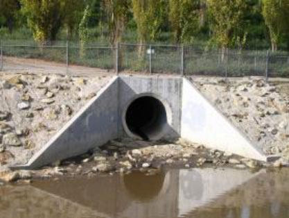
The CRS Coordinator’s Manual (Note 4) has more than 600 pages. Since the system is overburdened in cities and towns, and human resources are limited, Barnstable County officials hired a regional CRS coordinator. Rather than undertaking new projects such as expanding drainage channels or the construction of new buildings, the coordinator realized that it was possible to more quickly acquire CRS credits by making modifications to existing projects. One example of this is mosquito control. In Barnstable County, during the winter, 26 mosquito control personnel remove debris such as branches, leaves, mud, and sediment from 1,500 miles (approximately 2400km) of gutters and sewer pipes, ensuring rainwater drainage, thereby reducing the number of mosquito breeding sites (Fig. 2). This type of rainwater channel management is also very effective for flood mitigation. Through examining the situation, the coordinator and an assistant superintendent for the Cape Cod Mosquito Control Project realized that 15 municipalities could earn CRS credits by digitally mapping this annual channel maintenance (Note 5).
Residential property owners are able to reduce their premiums by 5-45% when communities earn CRS credits for reducing flood risk.
Outputs / Expected benefits
This approach is expected to lower flood insurance premiums and strengthen resilience to climate change.
Footnote
(Note 1) Nor'easter: A developed temperate cyclone that makes land on the Atlantic coast of the northeastern United States and Canada.
(Note 2) NOAA tide gauge at Woods Hole
https://tidesandcurrents.noaa.gov/noaatidepredictions.html?id=8447930
(Note 3) NFIP incurred $24 billion in debt from paying out claims related to several major storms, including Hurricane Katrina and Hurricane Sandy.
(Note 4) National Flood Insurance Program Community Rating System Coordinator’s Manual
https://www.fema.gov/sites/default/files/documents/fema_community-rating-system_coordinators-manual_2017.pdf
(Note 5) Currently, mosquito control teams photograph where they have completed work, then, using Geographical Information System (GIS) software, the coordinates are recorded and the data uploaded to a digital map.